Japan Earthquake: before and after satellite photo's

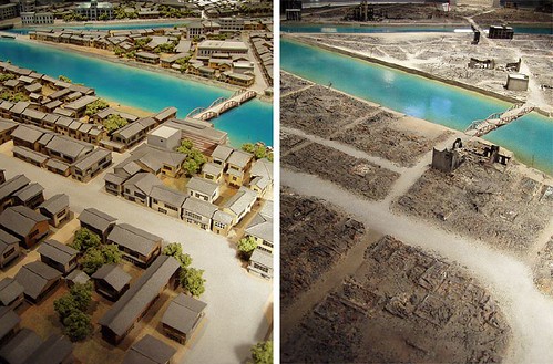
Unimaginable destruction. :(

Link 1 -

Move the blue slider to compare satellite images, taken by GeoEye, from before and after the disaster.

NYT: Satellite Photos of Japan, Before and After the Quake and Tsunami

Link 2 -

Hover over each satellite photo to view the devastation caused by the earthquake and tsunami.

ABC News: Japan Earthquake: before and after

121422143_4a9977c71a.jpg
 
looks like fail 3d modeling. the scale is way way off the mark. look at the size of the houses and the size of the river and bridge. where on earth will you find a bridge smaller than a house? and so small river? how big would humans be then? eh?
Also from a satellite viewing angle you can only take a pic looking downwards not sideways.

edit: my opinion was with ref. to the above image. not the images in links.
 
^I don't think so. Did you browse through the links? They pretty much depict the aftermath of the catastrophe through the images.
 
Gannu said:
^I don't think so. Did you browse through the links? They pretty much depict the aftermath of the catastrophe through the images.
I thought they were computer generated, checked out the link, seems not. What a bad tragedy has happened. I was reading in an article all of this is gonna lead to a Pole shift, with Brazil being the north pole.
 
Mephistopheles said:
Pole shift? Poles indeed shift but very slowly, and not overnight. And I dont think an earthquake has any say in this.
Do you know the poles used to shift about 10 miles a year in the 60's - 70's. Now The NP is shifting at 40 miles a year, towards Siberia.
 
Back
Top