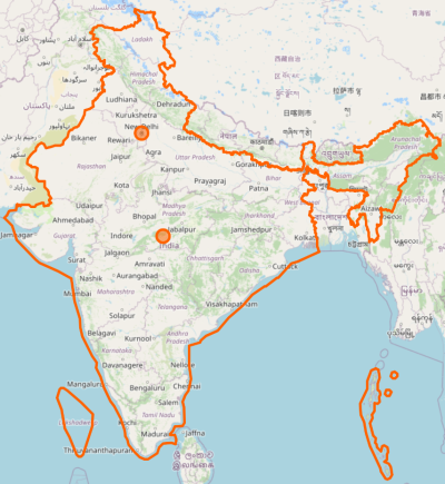
This best explains what I felt when I first saw that map. I found it shocking since I had never seen anything like that. In my book, the entire state belongs to India and nothing can change that pov. I still don't get why people in US and EU see a different map of India than what we Indians see.
Because they don't know the whole story. The Radcliffe line at partition cuts out J&K entirely and awards it to Pakistan which is the basis of the Pak claim. The understanding of people abroad ends there.
But as you know the ruler Hari Singh didn't consent to joining either side. So underhand methods were used. A
British major got things going by raising the Pakistan flag in the GB area. This began the Pak land grab and Hari Singh asked Nehru for help which would be forthcoming provided he agreed to accede his kingdom to India. Nothing new as over five hundred princely states had been through the same process. He agreed and thus began the military operations to defend the area. At the end a large portion of GB and Mirpur remained in Pakistan's control. It's worth studying this conflict as short of some truly heroic actions for which the first PVC's were awarded we never would have regained any of J&K. There's some new
books out that have go into more detail than was previously known.
There's quite a bit of criticism of the way how Nehru then chose to resolve the matter by approaching the UN as it was widely believed the Indian military could recover the occupied territory in a matter of weeks.
Nehru's idea of going to the UN was to get international recognition of J&K as part of India. In effect reverse the British decision to award entire J&K to Pakistan.
Otherwise it would look like an Indian land grab and bring into question the legitimacy of whatever parts of J&K India held at that point. The Brits drew the borders so who's to say the Indians wouldn't violate them again and claim more elsewhere.
A ceasefire was agreed at the UN and after a plebiscite was to be held. Before the plebiscite was to take place. The Pak side had to withdraw their forces first followed by the Indian side. Well, the Pak side never withdrew and that's where the matter ended. Thereby allowing India to remain in J&K as the terms of holding the plebiscite were never complied with by Pakistan.
So the reality is Pakistan failed to abide by the conditions of the plebiscite, an important fact they always forget to mention when claiming the entirety of J&K and saying plebiscite was never held and needs to be held now after they demographically re-engineered their part with Punjabis.
The Ladakh part was lost during the '62 war as we failed to prevent the road construction the Chinese initiated through Aksai Chin during the 50s to link Xianjiang with Tibet. The only way to link the two regions was to go through Aksai Chin. An area that owes nothing to the Brits and was won by dogra kings much earlier.
The J&K internet shutdown topic was also brought up out of nowhere!
Where
second, I posted that I didn't want politics here.
Have I done that? I don't know any other way to answer your question then.
The OSM map is there, yes, but we still don't know if this is intentional or not. Proton needn't show different maps to different users since J&K does belong to India. Is this a big deal? For most Indians it can be unless I am wrong in assuming this.
It is a big deal and even bigger when standing in Ladakh your location shows up as in China as occurred with Google services a while back.
That being said, I was in the wrong to write that Proton has done this "purposefully". We don't know and we can't accuse without any confirmation. To repeat, this thread is neither a critique of the quality of Proton apps nor a bashing of Proton AG.
It's probably an oversight which should be brought to their notice.


